
Science Campaigns
Delta-X combines airborne imaging, field data collection, and modeling in a multi-disciplinary study encompassing hydrology, sedimentology, geomorphology, and ecology.
Airborne instrument campaigns bring UAVSAR, AVIRIS-NG, and AirSWOT to Louisiana in 2021 to acquire data over the Atchafalaya and Terrebonne bay coastal wetlands and deltas, and field campaigns provide field measurements before, during and after the airborne campaign that are used for calibration and validation of models. Model development and calibration occurs throughout the project, progressing in step with the data acquisition.
Observational campaigns are scheduled to coincide with high river discharge (Spring 2021) and low river discharge (Fall 2021).
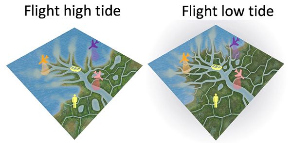
Within each campaign, the airborne radars acquire data at different stages in the tidal cycle to track the flow of water within a diurnal cycle. High and low discharge measurements document the change in inundation extent, flow velocity, sediment transport, and vegetation status with river stage.
Field data are acquired concurrently with the airborne campaigns. In addition, sediment accretion rates are measured starting from Spring 2019 and continuing through the end of the project with a validation campaign in 2022. Analysis is performed after each campaign.
The science team conducted Pre-Delta-X campaigns over the Mississippi River Delta in 2015 and 2016 to determine if each instrument could do the measurements it needs.
Campaigns
- 2015 & 2016: Pre-Delta-X campaigns (demonstrate measurements)
- 2021 (Spring): Airborne & field campaign
- 2021 (Fall): Airborne & field campaign
- 2022: Validation field campaign
Flights during rising and falling tides capture water seeping through wetlands and channel network.
Instruments
Delta-X utilizes three mature NASA airborne instruments: UAVSAR, AirSWOT and AVIRIS-NG.
Instrument |
Details |
|---|---|
| UAVSAR (TRL 9) |
Type: L-band repeat-pass interferometry (full-pol, 6m resolution) Platform: Gulfsteam-III Measurement: Shallow bathymetry, above ground biomass (AGB), water surface velocity, and water surface-level change in wetlands used to invert friction coefficient and determine hydrological connectivity. |
| AirSWOT (TRL 9) |
Type: Ka-band interferometry Platform: King Air B200 Measurement: Centimeter-level surface elevation and surface slope to invert friction coefficient in open-water rivers and lakes. |
| AVIRIS-NG (TRL 9) |
Type: Imaging spectrometer (432 bands, 4m resolution) Platform: King Air B200 Measurement: Water concentrations of CDOM and sediments, and characterize vegetation type and structure. |
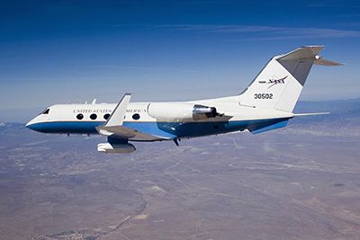
UAVSAR is an L-band synthetic aperture radar (SAR) with low noise, high spatial resolution, and excellent radiometric calibration. It will be used to map hydrological connectivity by mapping the networks of channels with minimum width of 10 m and by measuring water-level change in vegetated wetlands. The progression of water-level change is determined through InSAR time series analysis. Acquisition intervals of 15–30 minutes across 3–3.5 hours are planned to track water-level change across higher-magnitude tidal changes at temporal resolution commensurate with the hydrodynamic models.
AirSWOT is a Ka-band synthetic aperture radar used to measure water level change in areas of open water (river, channels, lakes, ponds). The data will be processed to produce continuous gridded elevation maps. We require slope errors less than 1.7 cm/km over 10 km reach; the combined measurement system yields errors smaller than 1 cm/km over 10 km reaches.
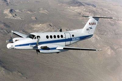
AVIRIS-NG is an imaging spectrometer with the most well-characterized spectral fidelity of any available instrument in its class. Data are calibrated and semi-empirical models are developed based on field water quality measurement to obtain a map of water quality (sediment concentration). Similar processing is performed to obtain an accurate map of vegetation structure and productivity.
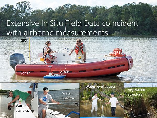
Field Data
We collect a large set of field measurements: water level, discharge, vegetation structure, channel bathymetry, ground elevation, and mineral and organic soil accretion rates.
During each campaign, AirSWOT and UAVSAR fly concurrently, with multiple flights timed to cover different phases of the tidal cycle to capture the time-varying spatial distribution of water flux in channels and wetland floodplains.
For cross-validation, we collect field water quality and associated handheld spectra during and within days of the AVIRIS-NG flights. Finally, we undertake in-situ-only measurements at the MRD in 2023 to validate model predictions of soil accretion across a multi-year interval.
We have funded a fully executable second year of spring and fall airborne campaigns, which we have baselined for 2023, that could be flown in any year after 2021 campaign in case of a major disturbance (e.g. hurricane between spring and fall 2021).