Modeling
Delta-X’s science goal is to quantify the mesoscale patterns of soil accretion that control land loss and gain, and to predict the resilience of deltas under projected RSLR. Delta-X studies delta evolution at the mesoscale, here defined as the level of the hydrogeomorphic zone (~1 ha).
We achieve the objectives by calibrating the open-source hydraulic, sediment transport, and land-evolution Delft3D model and ecogeomorphic numerical soil accretion models with data from state-of-the-art airborne remote sensing methods, namely interferometric synthetic aperture radar (InSAR) and imaging spectroscopy, and in situ field observations.
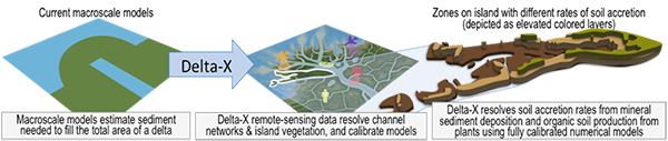
By achieving its objectives, Delta-X determines the roles of vegetation and channel structure in soil accretion and calibrates models that can spatially resolve and predict rates of accretion in deltas to the year 2100. Delta X moves beyond macroscale (~1000 km2) predictions, providing predictions at the scale of the hydrogeomorphic zone (~1 ha), increasing resolution by a factor of 105 and modeling soil accretion processes at the scale at which they occur. In this way, it enables prediction of land loss or gain within a delta, commensurate with coastal remediation projects. Engagement with an application end user partner, The Water Institute of the Gulf, is included to transition the science results of this study to the community engaged in sustainability efforts in the MRD.
From bathtub to ecogeomorphic scales
Delta-X makes breakthrough advances in the study of deltaic evolution, moving beyond coarse areal averaging of delta mass balance, to resolve mesoscale features using remote-sensing and field measurements.
This cross-disciplinary study, encompassing hydrology, ecology, and geomorphology, calibrates numerical models of sediment transport, ecological production, and soil accretion.
Soil accretion
Soil accretion is dominated by two processes:- Trapping and deposition of mineral sediments delivered by the distributary channel network at a rate, qs.
- Accumulation of organic matter (P) generated by local plant growth (roots and litter).
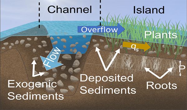
Soil accretion is from exogenic sediments trapping and plant production.
Hydrogeomorphic settings
An island (here Mike Island in the Wax Lake Delta) is characterized by multiple elevation zones—called hydrogeomorphic zones—that are generally classified as subtidal, high- and low- intertidal, or supratidal based on elevation.
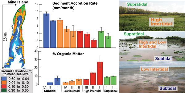
The hydrogeomorphic zones are characterized by distinct vegetation and channelization, and hence different productivity and sediment flux and deposition, resulting in different sediment accretion rates.
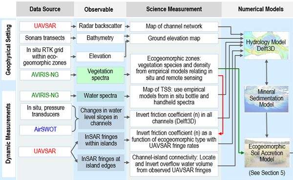
The Delta-X framework implementation
Delta-X calibrates a hydrology and ecogeomorphic model with remote-sensing and field data. Two airborne radar instruments observe the water surface elevation changes, and an imaging spectrometer measures vegetation type and structure and sediment concentrations in water.
Modeled water-surface elevation and slopes are compared to remotely sensed observations to invert the friction coefficient. The hydrology model’s mineral sedimentation rate outputs are used as inputs in the ecogeomorphic model.
Once the numerical eco¬geo¬morphic model is calibrated, it is run independently of observations to predict long-term soil accretion under projected RSRL, river discharge, and sediment supply.
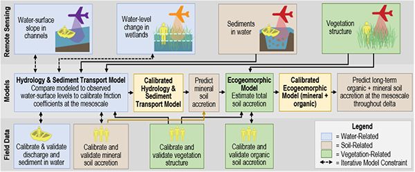
The Delta-X framework implementation uses airborne remote sensing and field measurements to calibrate hydrodynamic and ecogeomorphic models. The airborne observations capture rapid hydrodynamic processes occurring at the through the coastal continuum, driven by the river discharge and ocean tides.
Data from UAVSAR, AVIRIS-NG and AirSWOT and field measurements are used to invert or generate the required input layers for numerical models.