
Science Overview
The Delta-X mission seeks to answer this science question: What are the hydrological and ecological processes responsible for the resilience and vulnerability of river deltas to Relative Sea Level Rise (RSLR), and what are their relative contributions to soil elevation?
The mission’s objectives are to evaluate the roles of:- Vegetation on soil accretion rates
- Channel-network density and deltaic island size on soil accretion rates
Methodology
- Investigate the Atchafalaya basin (part of the Mississippi Delta) using full physics hydrologic and ecogeomorphic numerical modeling, calibrated at the deltaic mesoscale with state-of-the-art remote sensing and field observations.
- Model calibration is performed by calibrating model parameters to obtain water surface matching the remote sensing observations of water surface level, changes and slopes.
- Delta-X delivers fully calibrated hydrology and ecogeomorphic models of the basin.
- The calibrated models will be used to forecast which parts of the Mississippi River Delta will drown and which will survive under sea level rise.
Understanding and mitigating the impact of the relative sea level rise on coastal deltas is urgent. If ignored, RSLR will very soon have devastating consequences on the livelihood of the half billion people that live in these low-lying coastal regions.
Simple macro-scale models project that nearly all the world’s major river deltas will drown this century, along with the services they provide: flood protection, carbon sequestration, biodiversity and food supply.
However, these models fail to account for portions of deltas that have the ability to maintain and build land by trapping mineral sediment carried by the channel network, and accumulating organic soils produced as plants grow (sequestering carbon). We lack the synoptic measurements of water fluxes, sediment fluxes and plant productivity that are necessary to spatially resolve the scales at which soil accretion processes operate.
Science Campaigns
The NASA Delta-X Mission combines airborne imaging and in situ field measurements to calibrate hydrodynamic, sediment transport and ecological models. Delta-X conducted two airborne campaigns with 3 remote sensing instruments: UAVSAR, AirSWOT and AVIRIS-NG. The science team conducted Pre-Delta-X campaigns over the Mississippi River Delta in 2015 and 2016 to demonstrate the capabilities of the airborne measurements. The unique advantage of airborne remote sensing instruments is their ability to quickly repeat measurements.
UAVSAR and AirSWOT are radars that measure surface hydrology (water surface elevation and change) and AVIRIS-NG is an imaging spectrometer. The spectral images are used to determine the amount of sediment in water and the structure of wetland vegetation. In the Spring and Fall 2021 campaigns, these 3 sensors collected data near-simultaneously over the Atchafalaya and Terrebonne basins. In the case of Delta-X, radars repeated measurements of water surface elevation several times as tides came in and out of the channels and wetlands. The two campaigns were scheduled to capture different flood stages during the high Mississippi river discharge (Spring 2021) and low river discharge (Fall 2021) to document the change in inundation extent, flow velocity, sediment transport rates, and vegetation status with river stage. The flights were coordinated with in situ field measurements to calibrate and validate remote sensing measurements as well as models. This time-series of measurements are being used to develop new data assimilation methods and calibrate hydrodynamic and sediment transport models. In addition, sediment accretion rates are measured every 6 months starting from Fall 2019 through the last validation campaign in the Fall of 2023.
Campaigns
- 2015 & 2016: Pre-Delta-X campaigns (demonstrate measurements)
- 2021 (Spring): Airborne & field campaign
- 2021 (Fall): Airborne & field campaign
- 2023 (Fall): Validation field campaign
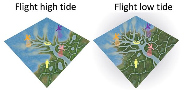
Flights during rising and falling tides capture water seeping through wetlands and channel network.
Instruments
Delta-X utilizes three mature NASA airborne instruments: UAVSAR, AirSWOT and AVIRIS-NG.
Instrument |
Details |
|---|---|
| UAVSAR (TRL 9) |
Type: L-band repeat-pass interferometry (full-pol, 6m resolution) Platform: Gulfsteam-III Measurement: Shallow bathymetry, above ground biomass (AGB), water surface velocity, and water surface-level change in wetlands used to invert friction coefficient and determine hydrological connectivity. |
| AirSWOT (TRL 9) |
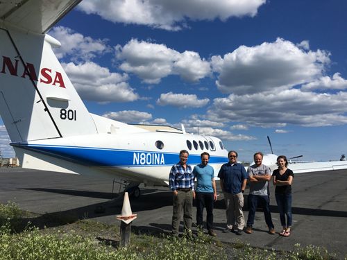
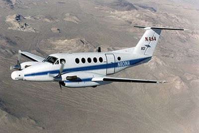
Type: Ka-band interferometry Platform: King Air B200 Measurement: Centimeter-level surface elevation and surface slope to invert friction coefficient in open-water rivers and lakes. |
| AVIRIS-NG (TRL 9) |
Type: Imaging spectrometer (432 bands, 4m resolution) Platform: King Air B200 Measurement: Water concentrations of CDOM and sediments, and characterize vegetation type and structure. |
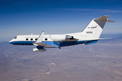
UAVSAR is an L-band synthetic aperture radar (SAR) with low noise, high spatial resolution, and excellent radiometric calibration. It will be used to map hydrological connectivity by mapping the networks of channels with minimum width of 10 m and by measuring water-level change in vegetated wetlands. The progression of water-level change is determined through InSAR time series analysis. Acquisition intervals of 15–30 minutes across 3–3.5 hours are planned to track water-level change across higher-magnitude tidal changes at temporal resolution commensurate with the hydrodynamic models.
AirSWOT is a Ka-band synthetic aperture radar used to measure water level change in areas of open water (river, channels, lakes, ponds). The data will be processed to produce continuous gridded elevation maps. We require slope errors less than 1.7 cm/km over 10 km reach; the combined measurement system yields errors smaller than 1 cm/km over 10 km reaches.
AVIRIS-NG is an imaging spectrometer with the most well-characterized spectral fidelity of any available instrument in its class. Data are calibrated and semi-empirical models are developed based on field water quality measurement to obtain a map of water quality (sediment concentration). Similar processing is performed to obtain an accurate map of vegetation structure and productivity.
Field Data
We collect a large set of field measurements: water level, discharge, vegetation structure, channel bathymetry, ground elevation, and mineral and organic soil accretion rates.
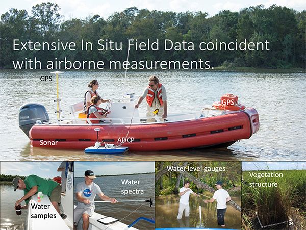
During each campaign, AirSWOT and UAVSAR fly concurrently, with multiple flights timed to cover different phases of the tidal cycle to capture the time-varying spatial distribution of water flux in channels and wetland floodplains.
For cross-validation, we collect field water quality and associated handheld spectra during and within days of the AVIRIS-NG flights. Finally, we undertake in-situ-only measurements at the MRD in 2023 to validate model predictions of soil accretion across a multi-year interval.
We have funded a fully executable second year of spring and fall airborne campaigns, which we have baselined for 2023, that could be flown in any year after 2021 campaign in case of a major disturbance (e.g. hurricane between spring and fall 2021).